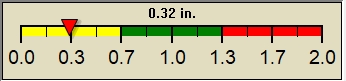
Current Weather Conditions - 7th & Bloomfield St. - Hoboken NJ

spacer

IMPERIAL | METRIC
Updated: 03-May-2026 @ 4:28pm  
Temperature Current Conditions Forecast
Currently Outside: Warmer 2°F than last hour.

60.3°F

---
High Today
60.6°F
4:19 PM
Low Today
45.5°F
7:06 AM
Yest High
64.0°F
2:31 PM
Yest Low
51.6°F
6:32 AM
Sta* High
93.7°F
2018
Sta* Low
47.0°F
2023
* This Station's Records Since 04/2016
Station Record Low
<!-- fixupCondition in='Mostly Sunny/Dry ' out='Mostly sunny, Dry' ocnt='2' --><!-- vals split on slash -->
Mostly sunny, Dry Mostly sunny, Dry

Wind from W Wind:  W
7.4

Gusting to:
14.0 mph
Current Rain Rain:
0.00 in
This
Afternoon
This Afternoon: Mostly Sunny
Mostly Sunny
Tonight

Tonight: Partly Cloudy
Partly Cloudy
Monday

Monday: Sunny
Sunny
Hi 62 °F Lo 49 °F Hi 74 °F
Current Radar
Hoboken Radar
Dew Point Liquid Precipitation Wind Speed Sun/Moon
Current: Decreased 0.9°F since last hour. 24.3°F
Last Hour: Decreased 0.9°F since last hour. 0.9°F
High 3:36 AM: 30.7°F
Low 11:30 AM: 21.0°F
Record High: 79.3°F on
8/13/2016
Record Low: -14.1°F on
1/31/2019
Wetbulb: 46.3°F
Rain Today
rain graph

Today: 0.00 in
Yesterday: 0.01 in
Last 7 Days: 0.17 in
May Rain: 0.01 in
May Avg: 3.71 in
Diff from Avg: Under 3.7 in for the month 3.70 in
Season: 7.76 in
Last YTD: 0.00 in
Last Rain
Time/Date:
5/2/2026
at 5:41 AM
31 rain days in 2026
1 day in May
1 day since last rain
Current: W  7.4 mph
1Hr Average: 5.7 mph
Wind Chill: 59.5°F
Wind Gust
Current: 14.0 mph
Today: 23.0 mph 11:41 AM
Month: 23.0 mph May-3
Year: 35.0 mph Feb-7
Record Gust: 50.0 mph
12/25/2020
Sunrise: 5:52am
Sunset: 7:54pm
Moonset: 6:28am
Moonrise: 9:25pm
Waning Gibbous
Waning Gibbous, Moon at 16 days in cycle
96%
Illuminated
Until Spring:
Mem Day Wknd:
Humidity Barometer
Current: Decreased 3% since last hour. 25%
Last Hour: Decreased 3% since last hour. 3%
High 7:00 AM: 53%
Low 3:57 PM: 25%
Record High: 97%
12/18/2016
Record Low: 10%
4/6/2021
Current: Falling 0.4  inHg/hr 1007.0 inHg
Last Hour: Steady
High 8:31 AM: 1009.1
Low 2:51 AM: 1006.7
Record High: 1045.0 inHg
2/13/2018
Record Low: 977.3 inHg
2/7/2020
Almanac Current UV Index Heat Index Cloud Height
Sunrise: 5:52 am
Sunset: 7:54 pm
Moonrise: 9:25 pm
Moonset: 6:28 am
Full Moon: 5/01/2026
2.2
Sunburn in
51 Minutes
Highest :
12:49 PM
6.3
Current Solar Energy
601 W/m2
92%
W/m2 SI Solar % SI
High Today:
12:27 PM
1329  W/m2
Record:
1440 W/m2
Current: 60.3°F
High 4:19pm: 60.6°F
Yesterday: 64.0°F
Record: 120.2°F
7/19/2020

8255ft.
  Weather Forecast  -   Outlook This Afternoon & Tonight
This
Afternoon
This Afternoon: Mostly Sunny
Mostly Sunny

Hi 62 °F
NWS forecast: Mostly sunny. High near 62, with temperatures falling to around 59 in the afternoon. Northwest wind around 20 mph, with gusts as high as 31 mph.
Tonight

Tonight: Partly Cloudy
Partly Cloudy

Lo 49 °F
NWS forecast: Partly cloudy. Low around 49, with temperatures rising to around 51 overnight. West wind 7 to 15 mph.
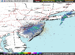
  Short Term Weather Forecast
Monday

Monday: Sunny
Sunny
Monday
Night
Monday Night: Mostly Clear
Mostly Clear
Tuesday

Tuesday: Mostly Sunny
Mostly Sunny
Tuesday
Night
Tuesday Night: Mostly Cloudy then Slight Chance Rain Showers
Mostly Cloudy then Slight Chance Rain Showers
Wednesday

Wednesday: Showers And Thunderstorms
Showers And T-Storms
Hi 74 °F Lo 59 °F Hi 83 °F Lo 63 °F Hi 69 °F