Weather Forecast -
Outlook This Afternoon & Tonight
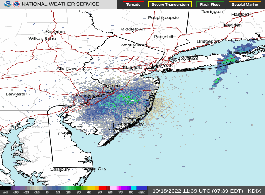
This Afternoon Chance Rain Showers
Hi 84 °F
NWS forecast: A chance of rain showers after 5pm. Partly sunny. High near 84, with temperatures falling to around 82 in the afternoon. Southeast wind around 15 mph. Chance of precipitation is 30%.
Tonight
Chance Showers And T-Storms
Lo 74 °F
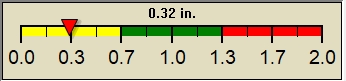
NWS forecast: A chance of rain showers before 8pm, then a chance of showers and thunderstorms between 8pm and 11pm, then a chance of showers and thunderstorms between 11pm and 2am, then showers and thunderstorms. Cloudy, with a low around 74. South wind 8 to 13 mph. Chance of precipitation is 80%. New rainfall amounts between a quarter and half of an inch possible.
Short Term Weather Forecast
Monday
Showers And T-Storms
Monday Night Showers And T-Storms Likely then Partly Cloudy