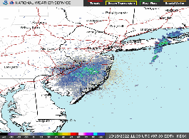
Current Weather Conditions - 7th & Bloomfield St. - Hoboken NJ
|
IMPERIAL |
METRIC
|
Updated: 03-Aug-2026 @ 4:58am | |||||||||||||||||||||||||||||||||||||||||||||||||||||||||||||||||||||||||||
| Temperature | Current Conditions | Forecast | ||||||||||||||||||||||||||||||||||||||||||||||||||||||||||||||||||||||||||
|
|
|
||||||||||||||||||||||||||||||||||||||||||||||||||||||||||||||||||||||||||
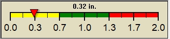
| Dew Point | Liquid Precipitation | Wind Speed | Sun/Moon | |||||||||||||||||||||||||||||||||||||||||||||||||||||||||||||||||||||||||
|
|
|
|
|||||||||||||||||||||||||||||||||||||||||||||||||||||||||||||||||||||||||
| Humidity | Barometer | |||||||||||||||||||||||||||||||||||||||||||||||||||||||||||||||||||||||||||
|
|
|||||||||||||||||||||||||||||||||||||||||||||||||||||||||||||||||||||||||||
| Almanac | UV Summary/Forecast | Heat Index | Cloud Height | |||||||||||||||||||||||||||||||||||||||||||||||||||||||||||||||||||||||||
|
|
|
662ft. |
|||||||||||||||||||||||||||||||||||||||||||||||||||||||||||||||||||||||||


| Weather Forecast - Outlook Overnight & Monday | ||||||||||
|
||||||||||
|
||||||||||
|
